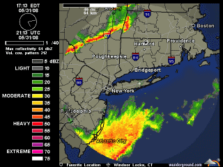
One of the items mentioned at today’s seminar on weather presented by Bill Babcock, was the pattern of early summer thunderstorms. He described how a line of storms holds together as it moves across eastern New York and western Massachusetts, but as it passes through eastern Connecticut and Massachusetts the colder air mass from Long Island Sound will cool the storm and cause it to lose a lot of energy. Bill said this generally happens near the I-495 area in Massachusetts, and I-395 in Connecticut. Also there are storms at the bottom of the image where he identified the warm water from the Gulf Stream
Take a look at this radar loop from this afternoon. It’s like the guy can predict the future!
(Image from wunderground)